
accidentally
US /ˌæksɪ'dentəlɪ/
UK /ˌæksɪ'dentəlɪ/
- Adverb
- Unexpectedly; by mistake
A2Moreaccurate
US /ˈækjərɪt/
UK /ˈækjərət/
- Adjective
- With no mistake or error; Correct
A2Moreacknowledge
US /ækˈnɑlɪdʒ/
UK /ək'nɒlɪdʒ/
- Transitive Verb
- To say you have received a letter, gift, etc.
- To say you accept the truth or value of something
A2Moreall along
US /ɔl əˈlɔŋ/
UK /ɔ:l əˈlɔŋ/
- Adverb
- From the beginning; all the time.
- Phrase
- In a line parallel to something long.
A2Moreapproval
US /əˈpruvəl/
UK /əˈpru:vl/
- Uncountable Noun
- Agreement that person/thing is acceptable
- Positive opinion of something or someone
A2TOEICMoreat best
US /æt bɛst/
UK /æt best/
- Phrase
- Under the most optimistic or favorable circumstances; the most that can be hoped for.
A1Moreat least
US /æt list/
UK /æt li:st/
- Adverb
- As a minimum
- Not less than
- Phrase
- No less than; at the minimum
- Used to indicate that something is positive in a bad situation.
C2Morebased on
US
UK
- Phrasal Verb
- To use something as the foundation or starting point for something else.
- Preposition
- Using something as the main idea or foundation.
- Relying on something as evidence or justification.
A1Morebias
US /ˈbaɪəs/
UK /'baɪəs/
- Noun (Countable/Uncountable)
- Preference to believe things even if incorrect
- A systematic error in a statistical result
- Transitive Verb
- To unfairly favor one view over another
- To cause someone to have prejudice
B1TOEICMoreborder
US /ˈbɔrdɚ/
UK /'bɔ:də(r)/
- Verb (Transitive/Intransitive)
- To be right next to another country or state
- To form the edge of something
- Noun
- Outer part or edge of something
- Line separating one country, state from another
A2TOEICMorecensor
US /'sensər/
UK /'sensə(r)/
- Transitive Verb
- To remove inappropriate material from books, films
- Noun
- An official who examines material and suppresses unacceptable parts.
B2Moreclaim
US /klem/
UK /kleɪm/
- Noun (Countable/Uncountable)
- To say that something is true, often without proof.
- A statement that something is true.
- Transitive Verb
- To demand or ask for something that you believe is rightfully yours.
- To take or cause the loss of (e.g., a life, property).
A2Morecolonialism
US /kəˈloniəˌlɪzəm/
UK /kəˈləʊniəlɪzəm/
- Uncountable Noun
- System in which a country controls a colony
B2Morecontest
US /ˈkɑnˌtɛst/
UK /'kɒntest/
- Noun
- Struggle or competition between rivals
- Verb (Transitive/Intransitive)
- To struggle or compete against other people
- To not accept an official or legal judgment
B1Morecorrect
US /kəˈrɛkt/
UK /kə'rekt/
- Adjective
- Being suitable and appropriate for an occasion
- True or accurate
- Transitive Verb
- To fix a problem
- To write marks on a piece of work to show mistakes
A2Moredecrease
US /dɪˈkris/
UK /dɪˈkri:s/
- Verb (Transitive/Intransitive)
- To reduce the size, amount or number of something
- Uncountable Noun
- Amount by which something has been reduced
B1TOEICMorediplomatic
US /ˌdɪpləˈmætɪk/
UK /ˌdɪpləˈmætɪk/
- Adjective
- Concerning formal relationships between countries
- Not being offensive
B1Moredisagree
US /ˌdɪsəˈɡri/
UK /ˌdɪsə'ɡri:/
- Intransitive Verb
- To have a different opinion; to fail to agree
B2TOEICMoredispute
US /dɪˈspjut/
UK /dɪ'spju:t/
- Verb (Transitive/Intransitive)
- To argue with someone about something
- To disagree about who owns or controls something
- Noun (Countable/Uncountable)
- Argument with someone about something
- A question or doubt about something
B1TOEICMoredomain
US /doʊˈmeɪn/
UK /dəˈmeɪn/
- Noun (Countable/Uncountable)
- A field of knowledge, thought or influence
- Area that a ruler or government controls
B1Moregenocide
US /ˈdʒɛnəˌsaɪd/
UK /ˈdʒenəsaɪd/
- Noun
- Deliberate destruction of a group of people
B2Morehave to
US /hæv tu/
UK /ˈhæv tə/
- Auxiliary Verb
- Must do
A1Moreignore
US /ɪɡˈnɔr, -ˈnor/
UK /ɪɡ'nɔ:(r)/
- Transitive Verb
- To not listen to, look at, or pay attention to
A2TOEICMorein reality
US /ɪn riˈælɪti/
UK /in riˈæliti/
- Phrase
- Actually; in fact; truly.
B2Morein the world
US /ɪn ði wɜrld/
UK /in ðə wɜː(r)ld/
- Phrase
- Used to emphasize a question expressing surprise, confusion, or disbelief.
- Used to indicate the extent or degree of something, often in a superlative sense.
A1Moreinfluence
US / ˈɪnfluəns/
UK /'ɪnflʊəns/
- Verb (Transitive/Intransitive)
- To affect or change something indirectly
- To persuade someone to do something.
- Noun (Countable/Uncountable)
- The power to affect what happens, to persuade etc.
- A person or thing that affects someone or something in an important way.
A2TOEICMoreinstead of
US /ɪnˈstɛd ʌv/
UK /inˈsted ɔv/
- Preposition
- When one thing is replaced by another
- Adverb
- As a substitute or alternative.
A1Moreinvade
US /ɪnˈved/
UK /ɪnˈveɪd/
- Transitive Verb
- To enter something causing a harmful result
- To enter (a country or region) so as to subjugate or occupy it.
B1Morelack
US /læk/
UK /læk/
- Verb (Transitive/Intransitive)
- To not have, or not have enough, of something
- Uncountable Noun
- The state of not having or not having enough of
A2TOEICMorelegitimacy
US /ləˈdʒɪtəməsi/
UK /lɪ'dʒɪtɪməsɪ/
- Uncountable Noun
- Legally allowed act; undisputed credibility
B2Morenegotiate
US /nɪˈgoʊʃieɪt/
UK /nɪˈgəʊʃieɪt/
- Verb (Transitive/Intransitive)
- To have a formal discussion to reach an agreement
- To manage a difficult task or path successfully
B1TOEICMoreobjective
US /əbˈdʒɛktɪv/
UK /əbˈdʒektɪv/
- Adjective
- Being real, rather than simply being an idea
- Not influenced by personal feelings or opinions; impartial.
- Noun
- Something you decide you want to do; goal
A2TOEICMoreoutrage
US /ˈaʊtˌredʒ/
UK /'aʊtreɪdʒ/
- Noun
- Very wrong or cruel act which causes great anger
- Transitive Verb
- To cause anger to due to wrong or cruel acts
B1Moreover time
US /ˈovɚ taɪm/
UK /ˈəuvə taim/
- Phrase
- Gradually; as time passes.
- During a long period.
- Adverb
- Gradually; as time passes.
B1Moreparliament
US /ˈpɑrləmənt/
UK /ˈpɑ:ləmənt/
- Noun
- Elected officials who govern a country (in the UK)
- Period when the Uk government is in session
A2Morephilosophical
US /ˌfɪləˈsɑ:fɪkl/
UK /ˌfɪləˈsɒfɪkl/
- Adjective
- Reacting calmly/reasonably if things are difficult
- Concerning philosophy
C1TOEICMorepolitical
US /pəˈlɪtɪkəl/
UK /pəˈlɪtɪkl/
- Adjective
- Being active or interested in government matters
- Diplomatic
A2Morepropaganda
US /ˌprɑ:pə'ɡændə/
UK /ˌprɒpə'ɡændə/
- Uncountable Noun
- (Use of) message that you want people to accept
- The systematic dissemination of information, especially in a biased or misleading way, in order to promote a political cause or point of view.
B1Moreregion
US /ˈridʒən/
UK /'ri:dʒən/
- Noun (Countable/Uncountable)
- Part of a country, of the world, area, etc.
- A part of the body
A2TOEICMorerely
US /rɪˈlaɪ/
UK /rɪ'laɪ/
- Intransitive Verb
- Depend on with full trust or confidence
- To trust or have confidence in someone.
B2TOEICMoreseize
US /siz/
UK /si:z/
- Transitive Verb
- To take a place with force, as by military action
- To arrest or catch someone
B1Moresole
US /soʊl/
UK /səʊl/
- Noun
- The part of your foot which touches the ground
- Flat fish commonly used as food
- Adjective
- Being the only one, as a survivor or inheritor
B1Morestagger
US /ˈstæɡɚ/
UK /ˈstægə(r)/
- Transitive Verb
- To greatly surprise someone
B2Morestamp out
US /stæmp aʊt/
UK /stæmp aut/
- Phrasal Verb
- To get rid of or make disappear
A2Moresubscribe
US /səbˈskraɪb/
UK /səb'skraɪb/
- Verb (Transitive/Intransitive)
- To regularly pay to receive a service
B1TOEICMoresummit
US /ˈsʌmɪt/
UK /'sʌmɪt/
- Noun (Countable/Uncountable)
- Official meeting(s) of the leaders of countries
- Highest part or top point of a mountain
- Verb (Transitive/Intransitive)
- reach the summit of (a mountain or hill).
B1Moretangible
US /ˈtændʒəbəl/
UK /ˈtændʒəbl/
- Adjective
- Able to be touched or felt; real
- Able to be seen or noticed; obvious; apparent
- Noun (Countable/Uncountable)
- Item which can be seen and touched
- A thing that is perceptible by touch.
B2Moreterritory
US /ˈtɛrɪˌtɔri, -ˌtori/
UK /'terətrɪ/
- Noun (Countable/Uncountable)
- Area of land defended by an animal
- Area of particular knowledge or experience
B1TOEICMoreturn to
US /tɚn tu/
UK /tə:n tu:/
- Phrasal Verb
- To go to someone for help, advice, or information.
- To start doing or using something, often something bad or undesirable.
A1Moreupcoming
US /ˈʌpˌkʌmɪŋ/
UK /ˈʌpkʌmɪŋ/
- Adjective
- Occurring soon; approaching
C1TOEICMoreversion
US /ˈvɚʒən, -ʃən/
UK /ˈvə:ʃən/
- Noun
- Different way that someone interprets something
- New or different form of something
A2TOEICMore
Vocabulary
- have to: Must do
- in the world: Used to emphasize a question expressing surprise, confusion, or disbelief.
- turn to: To go to someone for help, advice, or information.
- over time: Gradually; as time passes.
- at least: As a minimum
- all along: From the beginning; all the time.
- instead of: When one thing is replaced by another
- in reality: Actually; in fact; truly.
- based on: To use something as the foundation or starting point for something else.
- stamp out: To get rid of or make disappear
- at best: Under the most optimistic or favorable circumstances; the most that can be hoped for.
- subscribe: To regularly pay to receive a service
- accurate: With no mistake or error; Correct
- bias: Preference to believe things even if incorrect
- claim: To say that something is true, often without proof.
- version: Different way that someone interprets something
- parliament: Elected officials who govern a country (in the UK)
- influence: To affect or change something indirectly
- territory: Area of land defended by an animal
- lack: To not have, or not have enough, of something
- political: Being active or interested in government matters
- acknowledge: To say you have received a letter, gift, etc.
- ignore: To not listen to, look at, or pay attention to
- state: Region within a country, with its own government
- tangible: Able to be touched or felt; real
- region: Part of a country, of the world, area, etc.
- propaganda: (Use of) message that you want people to accept
- dispute: To argue with someone about something
- objective: Being real, rather than simply being an idea
- diplomatic: Concerning formal relationships between countries
- correct: Being suitable and appropriate for an occasion
- rely: Depend on with full trust or confidence
- approval: Agreement that person/thing is acceptable
- company: Good feeling from being with someone else
- accidentally: Unexpectedly; by mistake
- border: To be right next to another country or state
- sole: The part of your foot which touches the ground
- decrease: To reduce the size, amount or number of something
- domain: A field of knowledge, thought or influence
- seize: To take a place with force, as by military action
- invade: To enter something causing a harmful result
- philosophical: Reacting calmly/reasonably if things are difficult
- summit: Official meeting(s) of the leaders of countries
- public: Owned by the government
- genocide: Deliberate destruction of a group of people
- contest: Struggle or competition between rivals
- rise: To wake up and get out of bed after sleeping
- censor: To remove inappropriate material from books, films
- negotiate: To have a formal discussion to reach an agreement
- worse: Comparative of 'bad'; more bad
- legal: Concerning the law; allowed by law
- outrage: Very wrong or cruel act which causes great anger
- question: To ask for or try to get information
- mistake: Something done wrong/calculated wrong; error
- nation: Area or region controlled by a government and army
- annoy: To make someone angry
- legitimacy: Legally allowed act; undisputed credibility
- area: Amount of measured space
- world: All the humans, events, activities on the earth
- disagree: To have a different opinion; to fail to agree
- country: An area of land that is controlled by a government
- upcoming: Occurring soon; approaching
- lose: To be unable to keep in check or control something
- back: Farthest from the front e.g. in a classroom
- stagger: To greatly surprise someone
- colonialism: System in which a country controls a colony
Get the full experience in the app
Learn anywhere with detailed sentence and usage analysis
01:03
She took a brave step forward, leaving behind her comfort zone to chase her dreams.
Vocabulary
- brave
adj. Having courage
- comfort zone
phr. A familiar situation where one feels safe
Explanation
a brave step is a noun phrase, where brave is an adjective modifying the noun step, meaning "a courageous step".
forward is an adverb modifying step, meaning "ahead".
The whole phrase serves as the object, answering the "what" of took (verb) — she took a brave step forward.
Get the full experience in the app
Look up words anytime with pronunciation, part of speech, and usage
brave
US/brev/
UK/breɪv/
adj.Brave
v.t.To bravely face
A2 Elementary
Get the full experience in the app
Practice speaking anytime and get instant pronunciation feedback
Try this speaking exercise.
Try practicing with this sentence.
80
0
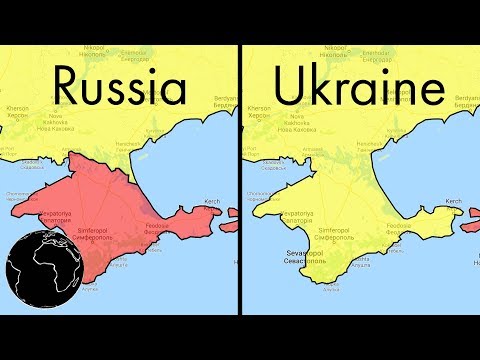
Samuel posted on 2018/03/09Ever wondered why Google Maps looks different in different countries? This video dives into the fascinating world of geopolitics and cartography, showing you how maps can be powerful tools in border disputes and international relations. You'll pick up advanced vocabulary while learning about the surprising influence of digital maps!
Learn this video on the APP!
The VoiceTube App has more in-depth practice for videos!