Placeholder Image

Subtitles section Play video

  • welcome to your latest video weather briefing from the National Weather

  • Service in San Diego

  • in this briefing we will talk about a significant weather pattern change to

  • bring showering and windy conditions

  • this is Alex Tardy from the National Weather Service in San Diego

  • what is this weather pattern now bring the significant change looks like

  • it's gonna start on Thursday

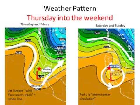
  • upper level trough of low pressure will carve across the west coast

  • and it towards southern california this will be tapped into some tropical

  • moisture

  • the system will then close off from the rest of the jet stream

  • and a slow and stall over our region or across the Baja region

  • this will draw an gusty easterly winds

  • and possibly additional precipitation into the weekend

  • where is that tropical moisture

  • well currently here's an image showing the tropical moisture already coming up

  • from Hawaii

  • tapped into the system that is now approaching Northern California

  • what are the impacts that we are expecting for the next several days

  • Tuesday through Sunday

  • well looks like the gusty easterly winds that develop on Friday

  • from the east and gusty especially for mountains passes and foothills

  • will continue right into the weekend for the most part

  • also have fog and low clouds are mainly be from the clouds intersecting

  • the terrain the mountain slopes and foothills

  • we will have a snow level that's rather high on Thursday that'll come down

  • on Friday and Saturday to around sixty five hundred feet

  • and perhaps a little bit lower for precipitation widespread showers are

  • expected for Thursday

  • and into Friday with a chance a front showers continuing

  • over the weekend the scale for impact is shown here

  • mainly from showers and the breezy to windy conditions

  • confidence is quite high all the way through Thursday and Friday and then it

  • decreases quite a bit

  • over the weekend due to low pressure system being stalled and to our south

  • here's a look at precipitation map

  • this is the expected precipitation for the next

  • several days so primarily this will be for Thursday and Friday

  • out this forecast period widespread precipitation up a quarter to half an

  • inch

  • with amounts close to an inch a little bit more

  • for favorite areas across our mountain locations as shown here

  • here are some links that you can use for resources for

  • looking at the latest graphical hazards across our area and digital forecasts

  • for various weather parameters you can also monitor the weather

  • and look at all the rainfall gages as well on the links provided here

  • for the latest watches advisories and warnings

  • also follow us on social media this has been Alex Tardy

  • with the National Weather Service

welcome to your latest video weather briefing from the National Weather

Subtitles and vocabulary

Click the word to look it up Click the word to find further inforamtion about it